The Northwest Territories — Aurora, Lakes and Diamonds
Capital: Yellowknife · Population: approximately 45,000 · Became a territory: 1870 (current form 1999)
The Northwest Territories is where a lot of Canadians send foreign visitors who want to see something distinctively northern. The capital is small and accessible (two-hour flight from Edmonton or Calgary), the aurora viewing is extraordinary, and the people who live here — a mix of Dene, Inuvialuit, Métis, and long-term southern transplants — tend to be welcoming in a way that feels specific to small northern places. The infrastructure is limited but better than most visitors expect. Yellowknife has restaurants and hotels that would hold their own in Regina or Saskatoon.
A Compact History
The Dene, Inuvialuit and Gwich'in peoples have lived across what is now the NWT for millennia. The Hudson's Bay Company entered the region in the late 1700s. Gold was discovered at Yellowknife in the 1930s, which is why the capital exists where it does. Diamond mines opened in the 1990s and early 2000s and, at their peak, made Canada the third-largest diamond producer in the world. The current boundary of the NWT dates from 1999, when Nunavut split off as a separate territory.

Yellowknife
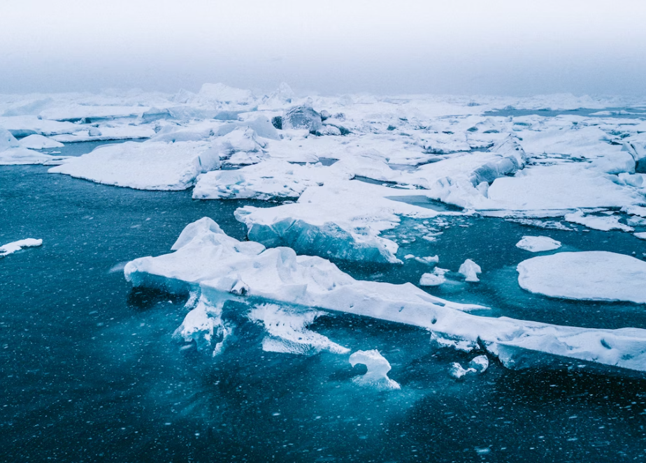
Yellowknife is the territorial capital, population about 20,000 — roughly half the population of the entire territory. It sits on the north shore of Great Slave Lake, the tenth-largest lake in the world by area and the deepest lake in North America (614 metres).
Why is Yellowknife the best place for the aurora?
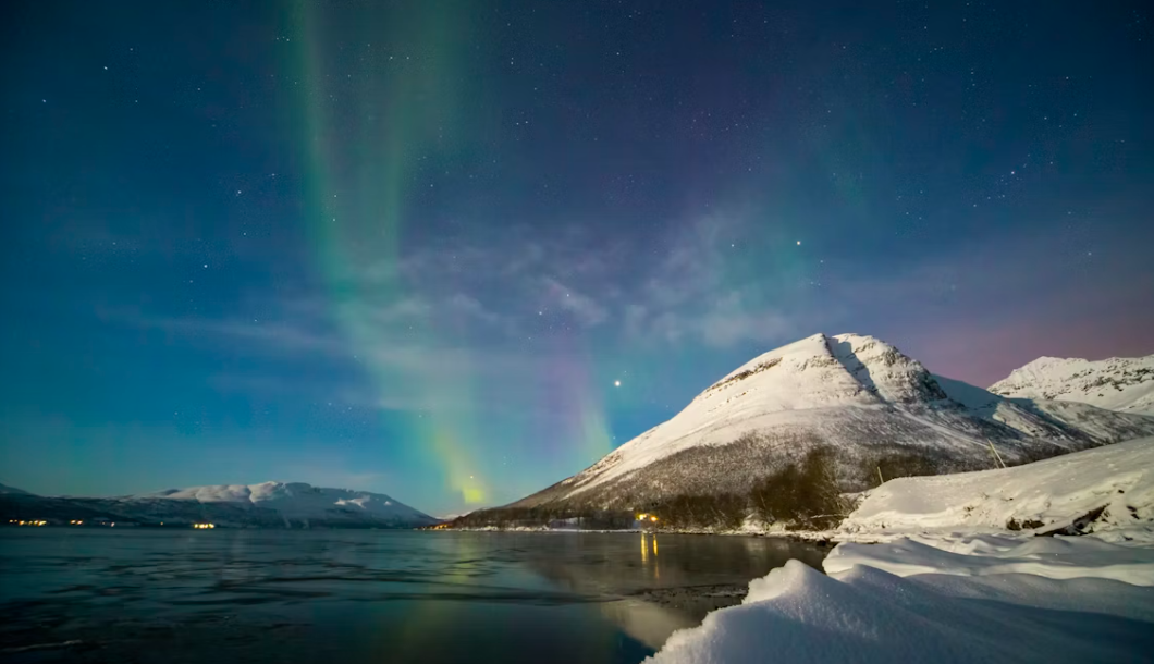
Three reasons. First, it sits directly underneath the auroral oval, the ring around the magnetic north pole where aurora concentrate. Second, it has very little cloud cover (Yellowknife averages more than 2,200 hours of sunshine a year, more than almost any Canadian city). Third, it's easily accessible by direct flight from several southern cities. The result is that mid-November through early April, aurora are visible on about 75-80 percent of nights — sometimes overhead, sometimes spectacular.
What should I do in Yellowknife besides chase the aurora?
Walk the Old Town — the original 1930s gold-rush town on Latham Island and around Back Bay, with houseboats frozen into the ice in winter. Climb the Pilot's Monument for the best overview of the city and the lake. Visit the Prince of Wales Northern Heritage Centre, a well-curated museum on the territory's Indigenous and settler history. Eat at Bullocks' Bistro, a ramshackle Old Town restaurant that serves Great Slave Lake whitefish and caribou. In summer, walk the Frame Lake Trail around the legislative building.
How do I get there?
Fly. Daily direct flights from Edmonton and Calgary (about 2 hours), and several times a week from Vancouver. Driving is possible — the Mackenzie Highway goes all the way from Alberta — but it's a 16-hour drive and only worth it if you have a specific reason.
How cold is Yellowknife in winter?
Cold. Average January high is -22°C, low -30°C. -40°C happens several times a winter. The dryness makes it more tolerable than Ontario damp cold at -10°C, but you need to dress for it: down parka, real boots (rated to -40°C), mitts not gloves, neck warmer, and a toque that covers your ears. Aurora tours provide heated suits and boots as part of the price.
Is summer worth visiting?
Yes, and it's underrated. Daylight runs more than 20 hours in June. Temperatures often hit 25°C. The lake is swimmable (briefly). Paddling, hiking, and the ice-road-turned-waterway experience in mid-July are all worth the trip. The disadvantage: no aurora in the midnight sun.
Most Popular Museum: Prince of Wales Northern Heritage Centre
The Prince of Wales Northern Heritage Centre on Frame Lake in Yellowknife is the territorial museum and archives — a comprehensive repository of the Northwest Territories' natural and cultural history housed in a building designed to echo the form of the boreal landscape. The centre's permanent galleries cover the geology of the Canadian Shield and the Mackenzie Valley, the archaeology and oral history of the Dene, Métis, and Inuvialuit peoples who have lived in this landscape for thousands of years, and the more recent history of European exploration, the fur trade, gold rush, and diamond mining that transformed the territorial economy.
The aviation history collection — particularly the bush plane section, documenting the pilots who opened the North to year-round travel in the 1920s and 1930s — is the best of its kind in Canada. The territorial archives, accessible to researchers, hold photographs and documents that cover the 20th century in the North with unusual completeness. Admission is free.
Your Best 5 Days in Yellowknife
Yellowknife divides its calendar into aurora season (October through April, when the skies are clear and the nights are long enough for the lights to perform) and summer (May through September, when it barely gets dark and the city spills outdoors onto the rocks and the lakeshore). Both seasons have a distinct character, and the city rewards repeat visits in both.
Old Town, Frame Lake & Heritage Centre
Yellowknife's Old Town, built on the rocky shores of Back Bay, is an anomaly — cabins, houseboats, and painted wooden houses on the granite outcrops of the Canadian Shield, a neighbourhood that looks like a prospector's camp that decided to stay. Walk from the Wildcat Café (the oldest restaurant in the NWT, open summers since 1937) down to the houseboat community on the water. Afternoon at the Prince of Wales Northern Heritage Centre. Dinner at Bullocks Bistro on Ragged Ass Road (the name is historical, the fish is excellent).
Aurora Viewing (Winter) or Midnight Sun (Summer)
Winter: book an aurora viewing tour with a lodge north of the city (Aurora Village, Blachford Lake Lodge, or one of the dozen others catering to the Japanese and European aurora tourism market). The average night above Yellowknife has more visible aurora hours than any other populated place in Canada. Summer: the midnight sun makes the city's Frame Lake trail and the rocks above Jackfish Lake glow at 11 p.m. in a way that makes sleep feel optional.
Dettah & Yellowknife Bay
Cross Yellowknife Bay to Dettah — the Yellowknives Dene community on the east shore, accessible by road in summer and by ice road in winter. The Dettah Ice Road (January–March) is one of the most famous ice roads in the world, crossing 8 km of Great Slave Lake ice. In summer, take the boat shuttle from the Old Town docks. The Dettah Heritage House and Dene cultural demonstrations run through the summer tourism season.
Prelude Lake & Cameron Falls
Prelude Lake Territorial Park, 30 km east of Yellowknife, has sandy beaches on a clear Shield lake — a genuinely stunning swimming hole on a hot summer day. Cameron River Falls, another 30 km east, is a thunderous cascade on the Prelude Lake outflow that is accessible via a 10-minute trail. The return route passes through the McNallie Creek canyon, a slot in the Shield that the road barely squeezes through.
Ticho Road & Departure
The Whatì all-season road (completed 2023) provides the first paved access to a Tłı̨chǫ Dene community — a landmark in territorial infrastructure. Drive the first 70 km to the Tłı̨chǫ Highway junction for a sense of what northern road-building means: raised gravel causeway over muskeg, bridges over Shield rivers, permafrost signs on the cut banks. Return to Yellowknife for an evening flight south on Canadian North or Air Canada.
Nahanni National Park Reserve
Nahanni, in the southwestern corner of the territory, is one of the most remote national parks in the country and the crown jewel of Canadian wilderness canoeing. Virginia Falls — twice the height of Niagara, surrounded by limestone canyons — is the park's centrepiece. The only way in is by float plane; full trips run two weeks on the river and are booked a year or more in advance.
Most Popular Museum: Nahanni Visitor Interpretation
The Nahanni National Park Reserve does not have a conventional museum, but the park's interpretive program — delivered through the Fort Simpson visitor reception centre and the seasonal ranger program — is the most effective gateway to understanding what makes Nahanni, one of UNESCO's original World Heritage Sites (1978), scientifically and culturally extraordinary. The Dene oral history interpretation, the geology of Virginia Falls (twice the height of Niagara) and the canyon's karst formations, and the biology of a northern wilderness that escaped glaciation and retains species assemblages found nowhere else make Nahanni the most scientifically significant park in the NWT.
Your Best 5 Days in Nahanni
Nahanni is accessible only by float plane or multi-week canoe expedition — and that inaccessibility is inseparable from its character. These five days assume a fly-in trip to Virginia Falls and the Rabbitkettle hotsprings, operated by Parks Canada and permitted outfitters.
Fort Simpson Gateway
Fly to Fort Simpson, the gateway community to Nahanni on the Liard River confluence with the Mackenzie. The Fort Simpson Dene Band has inhabited this confluence for millennia, and the Liard-Mackenzie confluence viewpoint from the island community is one of the great river views in the North. Evening preparation and gear check for the float plane departure.
Virginia Falls
Float plane to Virginia Falls — a 92-metre waterfall with a rock island splitting its crest, twice the height of Niagara and set in a canyon of Precambrian limestone. The morning mist in the canyon, the roar that you hear for a kilometre before you see the falls, and the complete absence of other people makes this one of the genuinely transformative wilderness experiences available in Canada. Camp at the Parks Canada campground above the portage.
Rabbitkettle Hotsprings
Float plane or canoe north to Rabbitkettle Lake, where geothermal springs have built travertine mounds over thousands of years — the largest such tufa mounds in Canada, up to 27 m high and 60 m in diameter. The mounds are fragile and the visit is guided by park rangers; advance permits are required. The lake itself is clear and cold except immediately around the spring vents.
First Canyon
Paddle or float plane to First Canyon, where the South Nahanni River cuts through a 1,000-m-deep canyon in the Mackenzie Mountains. The canyon walls are vertical in places, streaked with mineral oxidation in reds and yellows, and home to Dall sheep on the upper ledges. The canyon's thermal microclimate supports plant species normally found 500 km to the south.
Moose Ponds & Return
The headwaters of the Nahanni at the Moose Ponds alpine lakes, accessible by float plane from Virginia Falls, sit in a glacially sculpted cirque at the Yukon border. Moose, wolves, and grizzly bear are frequently seen in the boggy meadows around the lakes. Float plane back to Fort Simpson and evening commercial flight to Yellowknife or Edmonton.
Inuvik & the Mackenzie Delta
Inuvik sits north of the Arctic Circle at the top of the Dempster Highway, population about 3,200. Since 2017 it's been connected by road all the way to Tuktoyaktuk on the Arctic Ocean, the first all-season road in Canada to reach tidewater on the Arctic. The Mackenzie Delta, where North America's longest river meets the Arctic, is one of the most biologically productive places in the Arctic. Beluga whales come in by the thousands in July.
Most Popular Museum: Inuvialuit Cultural Resource Centre
The Inuvialuit Cultural Resource Centre in Inuvik is the primary keeper of Inuvialuit material culture, oral history, and archival records for the western Arctic coast. The centre's collection includes artifacts recovered from the Mackenzie Delta settlements, photographs from the early mission and trading post era, and a contemporary Inuvialuit art collection that represents the living tradition of carving, sewing, and beadwork that continues in Inuvik and the surrounding Delta communities of Aklavik, Fort McPherson, and Tsiigehtchic.
The Ingamo Hall, a community space in downtown Inuvik, hosts cultural events and sometimes opens its traditional crafts display to visitors. The Our Lady of Victory Church — the famous igloo church, a circular domed structure in downtown Inuvik designed to resemble an igloo — is not a museum but is the most photographed building in the NWT and worth a stop for its murals depicting the Stations of the Cross in the context of Inuvialuit culture.
Your Best 5 Days in Inuvik & the Mackenzie Delta
Inuvik sits 200 km above the Arctic Circle at the edge of the Mackenzie Delta — the third-largest river delta in the world, a maze of channels, ox-bow lakes, and willow islands covering 12,000 square kilometres. The delta is most accessible by boat in summer and by snowmobile in winter; Inuvik is the staging point for both.
Inuvik Town & Igloo Church
Fly to Inuvik via Canadian North from Yellowknife or Edmonton. Walk downtown: the igloo church, the Inuvialuit Cultural Resource Centre, and the covered boardwalk over the permafrost (the town is built on pilings to avoid melting the ground it rests on, and the boardwalk network is an engineering solution unique to Arctic towns). Evening at the Mackenzie Hotel restaurant or the Mad Trapper Pub.
Mackenzie Delta Boat Tour
Hire a local guide for a boat tour through the delta channels — the maze of sloughs, lakes, and mudflats that spreads from the main river into a 100-km wide fan at the Beaufort Sea. Muskrat houses dot the smaller channels; beluga whales enter the shallower delta arms in summer. The delta's spruce-and-willow landscape changes character completely between midsummer (green, mosquito-dense, lush) and late September (gold, still, caribou herds moving through).
Tuktoyaktuk Day Trip
Fly or drive the Inuvik-Tuktoyaktuk Highway (the first all-season highway to the Arctic Ocean, opened 2017) to Tuk — a community on a sand spit at the edge of the Beaufort Sea. Dip your feet in the Arctic Ocean. See the pingo national landmark — the world's highest concentration of pingos (frost-heaved ice-core hills) is visible from Tuk's shoreline. The community store sells the best maktaaq (beluga skin and blubber, a traditional Inuvialuit food) available anywhere.
Dempster Highway — Tombstone Area
Drive the Dempster Highway south toward the Yukon border — the gravel highway that crosses two mountain ranges and two major river ferry crossings on its 740-km route to Dawson City. The Tombstone Territorial Park boundary (140 km south of Inuvik) provides the most dramatic mountain scenery accessible from the Dempster. Grizzly bears and golden eagles are regularly seen from the highway in September.
Midnight Sun & Departure
In June and July, the sun does not set above the Arctic Circle for weeks. The midnight sun at Inuvik — walking along the Mackenzie River at midnight in full daylight — is one of Canada's most disorienting and memorable experiences. Hire a local photographer for a midnight shoot on the delta. Morning flight back south; the views of the delta from the air on departure are the best farewell the North offers.
Northwest Territories FAQs
When is the best aurora viewing?
Mid-February through mid-March is generally the sweet spot — cold, dark, and (statistically) the clearest. November through early December is also excellent. August and September can surprise you — the nights are dark enough late in August that aurora shows up over the lake, and the temperatures are still above freezing.
Is Yellowknife expensive?
Yes. A one-bedroom rents for over CAD $1,800; a week-long aurora trip (flight, accommodation, tours) from Toronto runs CAD $3,500 to $7,000 depending on package. Groceries are noticeably expensive because nearly everything is trucked up from Edmonton.
Can I drive the ice road?
The famous ice roads of the NWT — the winter-only routes north of the road system — are now mostly restricted to resource-industry traffic. The Tłı̨chǫ Highway, opened in 2021, replaced the ice road to Whatì. The Inuvik-Tuktoyaktuk ice road was replaced by the all-season highway in 2017. Some community ice roads are still open to casual traffic; check current conditions.
Are there diamond mines you can visit?
Not directly — the operating mines are industrial facilities and not open to tourists. The diamond industry funds a small Northern Frontier Visitors Centre in Yellowknife with displays on the mines and the cutting-and-polishing industry.

Education & Post-Secondary Institutions
The Northwest Territories has a small but vital post-secondary presence focused on distance education, trades training, and Indigenous knowledge, serving a dispersed population across communities separated by hundreds of kilometres of wilderness.
Aurora College
The NWT's primary post-secondary institution, Aurora College offers certificate and diploma programs in trades, health sciences, teacher education, social work, and business across three campuses and community learning centres. Its Aurora Research Institute supports science and research tailored to northern and Indigenous communities.
University of Arctic Studies / Partnerships
NWT students can access degree programs through partnership agreements with universities in southern Canada and through the University of the Arctic — an international network of circumpolar universities offering courses relevant to Arctic and northern life. Distance learning through Athabasca University is widely used.

Dechinta Centre for Research and Learning
A unique institution offering university credit courses taught on the land in Dene and Métis territories. Dechinta integrates Indigenous knowledge, languages, and practices with accredited academic content. Programs are delivered in partnership with universities including the University of Alberta and are recognized as a model for decolonizing post-secondary education.
Education in the NWT is shaped by extraordinary geographic realities: communities separated by hundreds of kilometres of roadless wilderness, eleven official languages, and the challenge of delivering quality schooling to populations where the majority of students are Indigenous. The territorial government funds K–12 schooling in every community, with Indigenous language instruction a growing priority. Students seeking degrees typically travel south or complete programs by distance — a pattern the government actively tries to mitigate through bursary programs and partnerships with southern institutions. The planned transformation of Aurora College into a polytechnic university — Ayamdigut University — represents the most significant investment in NWT post-secondary education in a generation.

Sports Teams & Athletic Culture
The NWT has no professional teams but an intense culture of Arctic traditional sport and community athletics. Yellowknife's outdoor skating culture and dog mushing traditions sustain sporting communities across enormous distances.
 AWG NWT
NWT at Arctic Winter Games
The NWT consistently sends competitive teams to the Arctic Winter Games, excelling in Arctic traditional sports — the one-foot high kick, Alaskan high kick, kneel jump and ear pull. These events descend from practical skills developed over centuries in subarctic conditions.
 NWT MUSH
NWT Sled Dog Racing
Sled dog racing is practiced seriously across the NWT, with races organized by communities along the Mackenzie River. The races are community events where drivers are known as well as the dogs they run.
 YK SKATE
Yellowknife Outdoor Skating
When Great Slave Lake freezes, Yellowknife residents skate on one of the largest outdoor rinks in the world. Ice roads extend across to communities on the far shore. The skating culture — families, hockey players, recreational skaters — is a defining community institution against the cold.
Culture, Arts & Identity
The Northwest Territories has eleven official languages — the most of any Canadian jurisdiction — reflecting a cultural complexity that Ottawa often underestimates. The Dene, Métis and Inuvialuit peoples each have distinct cultural traditions, and Yellowknife has developed a multicultural character that draws newcomers from across Canada and around the world to work in mining, government and services.
Dene Culture
The Dene Nation encompasses the Chipewyan (Dënesųłı̨né), Tłı̨chǫ (Dogrib), Dehcho (Slavey), Sahtúot'ı̨nę (Sahtu) and other peoples of the NWT, each with distinct language and cultural traditions. The Dene have been on this land for at least 10,000 years and their relationship with it — the land ethic that governs hunting, fishing and resource use — shapes politics and resource negotiations in the territory to this day.
Aurora Viewing
Yellowknife sits directly under the auroral oval — the ring around the magnetic pole where aurora activity is most consistent. From roughly late August to April, the northern lights appear on clear nights with a frequency and intensity that exceeds most other accessible aurora destinations. The tourism industry has built around this, with heated viewing platforms and aurora forecasting apps, but the spectacle itself defies context: standing on the shore of Great Slave Lake at 2 AM watching green curtains sweep the sky is a genuinely overwhelming experience.
The Diamond Industry
The discovery of diamonds in the Lac de Gras area in 1991 fundamentally changed the NWT's economy. The Ekati mine opened in 1998, followed by Diavik and other operations. The mines have generated billions in revenue, funded Indigenous business development and reshaped Yellowknife as a professional and skilled-trades city. They've also required careful negotiation of environmental impacts on land used by the Tłı̨chǫ and other peoples for millennia.
The Northwest Territories' Hall of Icons
The NWT's hall of fame is small — a function of population, not of accomplishment. The leaders, artists and athletes below have shaped territorial life and pushed the territory's voice onto the national stage.
Stephen Kakfwi
WPView on Wikipedia →Sahtúot'ı̨nę Dene leader and former premier of the NWT. Kakfwi was a residential-school survivor, a folk-rock musician (his album Northern Sun received a Juno nomination), and a key negotiator of NWT devolution. A rare combination of policy-maker and artist.
Georges Erasmus
WPView on Wikipedia →Former National Chief of the Assembly of First Nations and co-chair of the Royal Commission on Aboriginal Peoples (1991–1996), one of the most influential Canadian public-policy reports ever produced. Erasmus shaped the modern self-government conversation across the country.
Richard Van Camp
WPView on Wikipedia →Tłı̨chǫ Dene novelist and storyteller (The Lesser Blessed, Whistle). Van Camp's voice — funny, profane, deeply Northern — has made him one of the most-read Indigenous writers in Canada. The novel The Lesser Blessed was filmed in Fort Smith with local residents in supporting roles.
Brendan Green
WPView on Wikipedia →Olympic biathlete who represented Canada at four Winter Olympics (2006–2018). Green grew up in Hay River and trained out of the Norwegian Olympic facilities; he and his sister Magdalena were the first siblings from the NWT to compete at Winter Olympics together.
Leela Gilday
WPView on Wikipedia →Dene singer-songwriter, two-time Juno nominee, and one of the most-listened-to Indigenous musicians in Canada. Gilday's North Star Calling won the Indigenous Music Award for album of the year. Her concerts in Yellowknife are sold-out community events.
Tom Jackson
IMDbView on IMDb →The Cree-Métis musician and actor whose Huron Carole concert tour has raised millions for Canadian food banks since 1987. Jackson lived for years in Yellowknife and remains a frequent presence at NWT cultural events.
Justice Thomas Berger
WPView on Wikipedia →The Mackenzie Valley Pipeline Inquiry, which Berger chaired, listened to thousands of Northerners and concluded that the pipeline should not be built without first settling Indigenous land claims. Its 1977 report reshaped Canadian Indigenous-rights law.
Ed Jeske & the Inuvik Sundogs
WPView on Wikipedia →The hockey program at Inuvik has produced more NHL-drafted players per capita than any town its size in Canada. Ed Jeske, the late hockey coach who built much of the system, is a legend in the Beaufort Delta. The Inuvik Sundogs remain a junior hockey power.
Regional Cuisine: What the NWT Actually Eats
Country food is the deep food culture of the NWT — caribou, moose, fish from the Mackenzie and Great Slave Lake, foraged berries. In Yellowknife and the larger communities, an interesting fusion has developed where traditional ingredients meet trained-chef techniques.
Whitefish from Great Slave Lake
The lake yields some of the best lake whitefish in the world. Fileted, lightly fried, served with potatoes and peas. Bullocks Bistro on the Yellowknife houseboat dock is a local institution and serves the most authentic version.
Caribou & Muskox
Caribou is the staple country meat across the territory. Slow-roasted, made into stew, dried as jerky or sausage. Muskox — a more recent commercial product — is rich and gamey. Trader's Grill and the Rover Restaurant in Yellowknife often feature one or both on tasting menus.
Bannock
The Indigenous quickbread of the North, fried golden in pork fat and served with dried meat or jam. The Trapper's Cabin in Old Town Yellowknife or any cultural event in the territory will have it.
Arctic Char
The polar fish — firm-fleshed, deeply pink, less oily than salmon. From Hay River, Wha Ti and Inuvik area lakes. Pan-fried with butter and lemon, or smoked.
Cloudberries (Mossberry, Bakeapple)
The amber-orange tundra berry, picked in late summer along the muskeg edges. Made into jam, baked into pies. Not common outside the North; even rarer in southern Canada.
The Dish on a Houseboat
Yellowknife's Old Town houseboat community — about 50 boats, mostly inhabited year-round, frozen into the lake all winter — has its own informal food culture: the BBQ Beach in summer, ice-cellar caribou in winter, and a generous neighbourly tradition of dropping fish off at the next dock.
Top 10 Restaurants in Northwest Territories
Yellowknife's restaurant scene is small — perhaps two dozen places that serve dinner, total — but it's more interesting than the population would suggest. The mix of cooks who came north for the diamond mines and stayed, the Indigenous chefs working with country foods, and the steady stream of visitors here for the aurora has produced a small group of rooms worth seeking out. Outside Yellowknife, dinner options thin quickly; what follows is mostly capital-city, with one Hay River entry to round out the territory.
Bullocks Bistro
On the Old Town waterfront, Bullocks is the most-talked-about restaurant in the territory. The space is tiny — fourteen seats — and the menu is built almost entirely around fresh-caught Great Slave Lake fish: arctic char, lake trout, pickerel, whitefish. The walls are covered in dollar bills signed by visitors. There are no reservations and the wait can be long; it's worth it.
Trader's Grill
The dining room of the Explorer Hotel runs the most ambitious northern-Canadian menu in town — bison short rib, muskox tenderloin, Arctic char, country foods integrated into a continental presentation. The wine list is the best stocked in the territory. It's the room where Yellowknife's professional class entertains visitors.
The Woodyard Brewhouse & Eatery
NWT Brewing Company's brewpub in Old Town serves house-brewed beer next to a serious kitchen — bison burgers, smoked-fish charcuterie, hand-cut fries — with a deck overlooking Great Slave Lake. In summer the deck is the social hub of Old Town; in winter, the wood stove inside is the draw.
Le Frolic Bistro & Bar
A French bistro in downtown Yellowknife that is more credible than its location would lead you to expect. Steak frites, mussels, a wine list that takes the Rhône seriously, and a Quebec-trained kitchen. It's the closest the territory gets to a city-style date-night room.
Bullock's Bistro Take-Two: Coyote's Bistro
The Chateau Nova's in-house dining room has quietly become one of the more reliable dinners in town for visitors who don't want to compete for a Bullocks seat. The kitchen does Arctic-influenced steakhouse cooking — caribou, char, prime rib — in a room that's larger and quieter than most options.
Wildcat Café
The 1937 log cabin café in Old Town is the most photographed restaurant in the territory, and the cooking — Arctic char, bison burgers, bannock — lives up to the building's history. Open only in summer, with picnic-table seating both indoors and out. It's a meal that doubles as a piece of territorial heritage.
Black Knight Pub
The Black Knight has been the city's downtown Scottish pub since long before the diamond boom, and the kitchen turns out fish and chips, shepherd's pie, and a Sunday roast that locals will defend against any city-style competition. It's a working pub, not a restaurant pretending to be one.
Dancing Moose Café
The Dancing Moose anchors the Old Town breakfast trade. The kitchen runs an all-day menu of substantial breakfasts — eggs Benedict variations, smoked-trout hash, sourdough French toast — and the patio in summer fills with visitors and locals alike. It's the morning meal that sets up an Old Town walking day.
Thornton's Wine & Tapas Room
A small wine bar in Old Town serving Spanish-influenced tapas — patatas bravas, croquetas, charcuterie — with one of the more carefully chosen wine lists in town. The room is dim and warm, and on a cold night it's the most adult-feeling dinner in Yellowknife.
Back Eddy Pub & Restaurant
Five hundred kilometres south of Yellowknife on Great Slave Lake's south shore, the Back Eddy in Hay River is the best dinner in the territory's second-largest community. The menu is unpretentious — fish and chips with locally caught pickerel, prime rib on weekends, a long list of beers — but the kitchen takes its sourcing seriously and the room overlooks the Hay River.
Whose Land Are You On?
The Northwest Territories is one of the few jurisdictions in Canada where Indigenous peoples make up roughly half the population. The territory is the homeland of the Dene Nation (in five major branches), the Inuvialuit of the western Arctic, and the Métis communities of the Mackenzie River.
The Tłı̨chǫ Self-Government
The Tłı̨chǫ Government, established by the 2005 Tłı̨chǫ Land Claims and Self-Government Agreement, was the first combined land-claims-and-self-government agreement in the NWT. The Tłı̨chǫ govern 39,000 km² of central NWT, including the four communities of Behchokǫ̀, Whatì, Gamètì and Wekweètì.
The Inuvialuit Settlement Region
The Inuvialuit Final Agreement of 1984 was the first comprehensive Inuit land claim in Canada — predating Nunavut by fifteen years. The Inuvialuit Settlement Region covers the Beaufort Sea coast and includes the communities of Inuvik, Tuktoyaktuk, Aklavik, Paulatuk, Sachs Harbour and Ulukhaktok.
The Sahtu and Gwich'in Settlements
The Sahtu Dene and Métis Comprehensive Land Claim (1993) covers the Great Bear Lake region. The Gwich'in Comprehensive Land Claim (1992) covers the Mackenzie Delta and includes Tsiigehtchic, Aklavik, Inuvik and Fort McPherson.
Dehcho and Akaitcho: Still in Negotiation
Two large Dene regions — the Dehcho (Slavey) along the upper Mackenzie River and the Akaitcho around Yellowknife and the southeast — are still in active land-claim negotiations. The complexity is part of why politics in the NWT is so locally significant.
Your Best 5-Day Stay in the Northwest Territories
The NWT is enormous — five days will only show you the area around Yellowknife and the Great Slave Lake. That's still a remarkable trip. The itinerary below assumes a winter visit (the aurora is best from late August to April) but most of it works year-round; in summer, the canoe trips and boat tours replace the aurora viewing.
Yellowknife — Old Town and Frame Lake
Fly into YZF. Drop bags downtown (the Explorer Hotel or the Chateau Nova). Walk Old Town: the houseboat community on Yellowknife Bay, the Wildcat Café (closed in winter, an institution in summer), the Pilot's Monument on the Rock for the panoramic view.
Lunch at Bullocks Bistro for the lake whitefish. Afternoon at the Prince of Wales Northern Heritage Centre — the territorial museum, with one of the strongest Dene and Inuvialuit collections in the country. Dinner at the Dancing Moose Café or Trader's Grill.
Aurora Night One — Aurora Village or Blachford Lake
Spend the day relaxing or visiting the Legislative Assembly building. By 9 p.m., be at the Aurora Village heated tipis 30 minutes outside town, or take a chartered float plane to Blachford Lake Lodge for a more remote experience.
Aurora viewing is a midnight-to-3-a.m. activity. Dress for the cold — even when it's -35, the spectacle is worth it. Hot drinks, blankets and a warm-up cabin are part of the package.
Drive the Ingraham Trail & Cameron Falls
The Ingraham Trail (Highway 4) east of Yellowknife winds through the boreal Shield to Cameron Falls and Reid Lake. In winter, the Ice Road across Great Slave Lake to Dettah is the more remarkable drive — driving on the lake itself, with the cracks and ice noises beneath you.
If you've booked a dogsledding tour, today is the day. Beck's Kennels and Snowking's Castle (the annual ice castle on the lake, March-only) are local institutions.
Aurora Night Two & the Snowking's Castle
The aurora wins on the second viewing — you've seen it once and now you can simply enjoy it. Take a different vantage: the deYellowknife winter beach if you stayed in town, or a remote lakeshore from a chartered tour.
Earlier in the day, visit the Old Stope Saloon (the houseboat district's pop-up bar in winter) and walk the Frame Lake trail. Dinner at the Black Knight Pub for British-pub comfort food.
Hay River or Departure
If you have appetite for one more drive, head south to Hay River (5 hours) on the southern shore of Great Slave Lake — a fishing-and-rail town with the Twin Falls Gorge Territorial Park nearby and the Alexandra Falls just before town. The drive itself crosses the boreal forest.
Otherwise, fly out of Yellowknife in the late afternoon — the southbound flights to Edmonton and Calgary leave a small flotilla of bush planes and government turboprops behind you. The territory will have changed your sense of how cold a country actually is.
Five Days in Yellowknife
Yellowknife is the only city in the territories large enough to repay an unhurried five-day stay, and it rewards visitors who slow down. Half the appeal sits inside the Old Town's painted houseboats and the granite shores of Great Slave Lake; the other half is the surrounding wilderness, accessible from the city in under an hour by car or floatplane. Winter (mid-November to early April) is the aurora window. Late June and July give you the midnight sun, the houseboat regatta and the open patios. The shoulder months are the bargain.
Old Town & the Bush Pilots' Monument
Drop your bags at the Explorer Hotel or the Chateau Nova downtown, then walk down Franklin Avenue toward Old Town. The road bends past the floatplane base and drops you into the Rock — the granite outcrop the original mining settlement clung to in the 1930s. Climb the wooden steps to the Bush Pilots' Monument for the postcard view of Yellowknife Bay, the houseboats and the Back Bay airstrip.
Lunch at Bullocks' Bistro on the waterfront — the deep-fried Great Slave Lake whitefish on a paper plate is the only correct order. Walk the houseboat causeway to Latham Island and back. Dinner at the Wildcat Café (May to September) or the Black Knight Pub the rest of the year, then a sky check from Pilot's Monument before bed.
Prince of Wales Northern Heritage Centre & Frame Lake
Spend the morning at the Prince of Wales Northern Heritage Centre, the territorial museum overlooking Frame Lake. The Indigenous galleries — Dene, Inuvialuit, Métis — are the most thorough in the country and the bushplane exhibit makes sense of every airstrip you'll see for the rest of the trip. Lunch at the Heritage Centre café, then walk the Frame Lake loop (8 km, mostly flat) past the Legislative Assembly and the city's quiet centre.
In the afternoon, the Legislative Assembly building is open for tours; the round chamber with the Inuit-art polar bear at its centre is the architectural set piece. Dinner at the Trader's Grill in the Explorer Hotel, the standby for Yellowknife visitors since the 1970s.
Ingraham Trail & Cameron Falls
Rent a car and drive the Ingraham Trail, the only highway out of Yellowknife. The road dead-ends at Tibbitt Lake, 70 kilometres east, and along the way sits a string of Canadian Shield lakes that locals fish, paddle and ice-skate depending on the season. The Cameron Falls trail (4 km return) is the must-do hike — a short boardwalk through black spruce drops you at a 17-metre falls that runs all summer.
Stop at Prelude Lake for a swim if it's July, or at Reid Lake to watch the float planes drop in. Back in town, dinner at Sushi North (yes, sushi, in Yellowknife — the salmon is from BC and the menu has bowhead-whale carpaccio if you're brave) or at Twist on the waterfront.
Aurora Night or Midnight Sun Paddle
This is the day you came for. In winter, book an aurora package with Aurora Village or Beck's Kennels — the chalets sit 25 minutes north of the city under the auroral oval, propane stove going, blankets stacked, and the lights almost guaranteed any clear night between November and March. Three to five hours is the typical viewing window; the cold is the part you have to plan for.
In summer, swap that out for a midnight-sun canoe paddle on Long Lake or a Great Slave Lake fishing charter — the lake holds trophy lake trout and pike, and the captains are usually third-generation locals with stories. Whichever season, dinner before the show at Le Frolic, the long-running French-Canadian bistro on 50th Avenue.
Old Town Glassworks, NWT Brewing & Departure
A slower last day. Old Town Glassworks turns recycled wine bottles into etched glassware and runs hour-long workshops you can drop into; you walk out with the souvenir you actually use. NWT Brewing Co. (also the Woodyard restaurant) sits on the lakeshore in Old Town and is the right place for the last lunch — the bison sausage on the chalkboard menu is a Yellowknife rite of passage.
The territorial seat of government feels small until you walk Franklin Avenue one last time and notice the licence plates from twenty different communities, the bush pilots in coveralls at the coffee counter, and the Dene drum group practicing in the park. Yellowknife's airport check-in is unfussy; give yourself an hour.
Commerce & Industry
The Northwest Territories is a jurisdiction of vast geography and concentrated settlement, where the government is the largest single employer, where diamond mines drive the formal private economy, and where the traditional economy — hunting, trapping, fishing, gathering — remains genuinely important in ways that southern Canadians can find difficult to comprehend. Economic development here means something different than it does in Ontario: it means building roads where there are none, keeping fuel affordable when it costs twice the southern price, and finding ways to let communities participate in the resource economy on their own terms.
1. Diamond Mining
The discovery of kimberlite pipes in the Lac de Gras area in 1991 transformed the NWT's economy. Ekati (operated by Arctic Canadian Diamond Company) and Diavik (Rio Tinto) are among the world's top diamond-producing mines by both volume and value. At peak production in the early 2000s, the NWT was producing 15 percent of the world's diamonds by value. The mines have created thousands of direct jobs and a procurement opportunity for Indigenous businesses under Impact Benefit Agreements that were groundbreaking at the time and remain models for the industry.
2. Government & Public Sector
The Government of the Northwest Territories (GNWT) is the largest employer in every community outside Yellowknife, and in Yellowknife itself employs a large share of the working-age population. Federal departments — Indigenous Services Canada, RCMP, National Defence, Transport Canada — add a substantial federal public sector layer. In a territory where private sector employment is limited by geography and market size, the public sector provides the economic floor beneath which the standard of living cannot fall without federal intervention.
3. Tourism
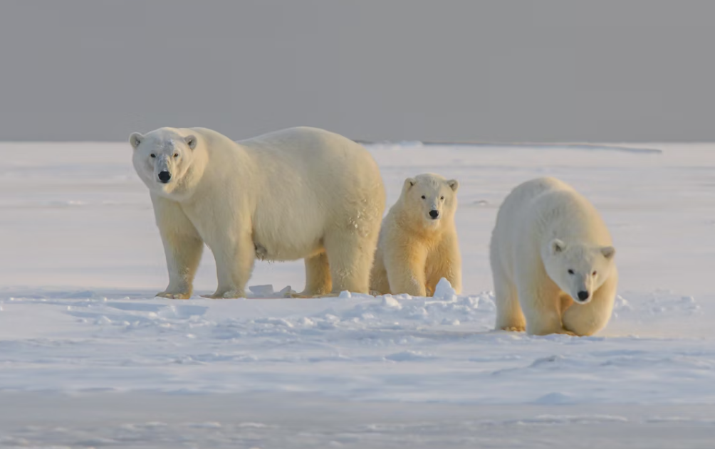
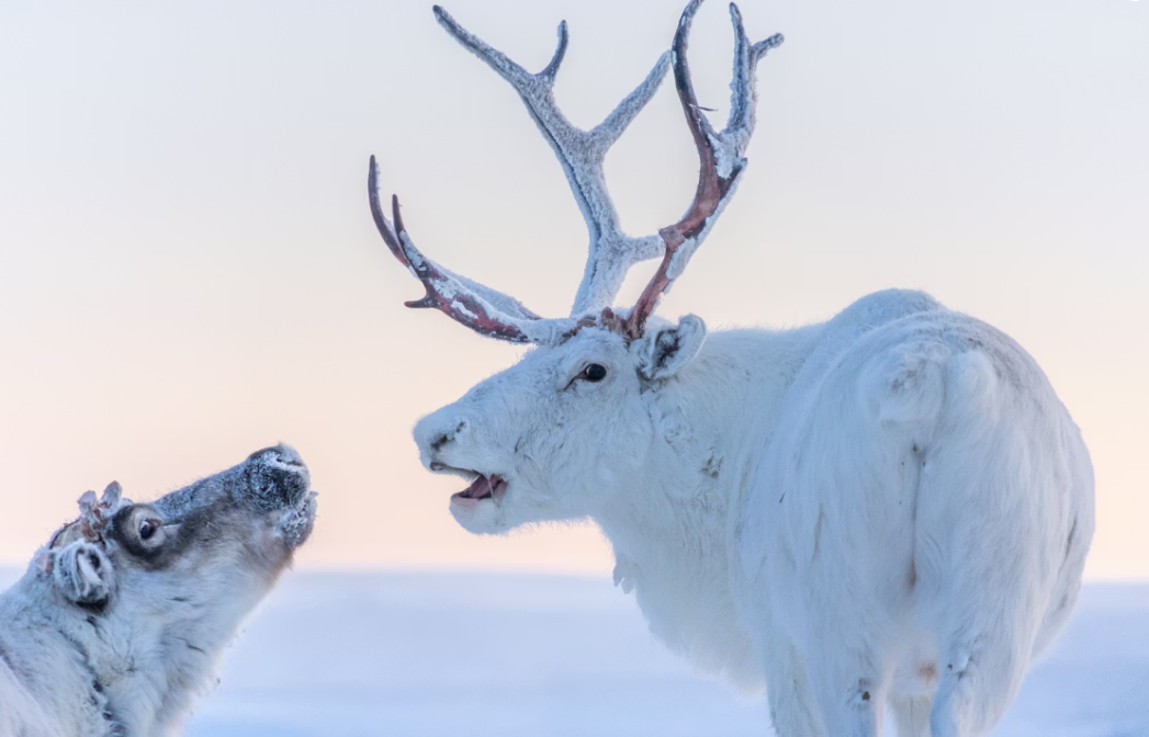
The NWT has quietly become one of the world's premier aurora borealis viewing destinations. Yellowknife sits under the auroral oval, with more clear nights per aurora season than almost anywhere on earth, and a string of wilderness lodges outside the city have built a sophisticated international tourism product around it. Beyond aurora, the NWT offers Nahanni National Park Reserve (a UNESCO site of towering canyon walls and one of North America's most spectacular wilderness rivers), paddling the Mackenzie, and wildlife watching that includes wood bison, caribou, muskox, grizzly, and wolverine.
4. Oil & Gas
Norman Wells on the Mackenzie River has been producing oil since 1920 — making it one of Canada's oldest petroleum fields. Production has declined significantly, but the Sahtu region around Tulita has been the focus of new shale and tight oil exploration. The long-proposed Mackenzie Gas Project, which would build a pipeline from the Mackenzie Delta to the Alberta grid, has been in planning and environmental review for decades without proceeding, held up by a combination of economics, Indigenous land rights negotiations, and southern politics.
5. Mining — Gold & Other Minerals
The Giant Mine and Con Mine in Yellowknife were the foundation of the territorial economy for decades; Giant's closure left a legacy of arsenic trioxide contamination that is one of Canada's most expensive environmental remediation projects. New gold exploration in the Slave Geological Province has identified significant deposits, and the Nighthawk Lakes area near Yellowknife has attracted junior miners. The Mackenzie Valley also holds lithium brines of growing interest to battery manufacturers.
6. Construction
Building and maintaining infrastructure in the NWT is a perpetual economic driver. The Mackenzie Valley Highway, sections of which remain unbuilt, is the territory's most significant infrastructure ambition. The Tłı̨chǫ all-season road to Whatì was completed in 2023 and is being extended toward Whatì and Gamèti. Housing construction in Yellowknife, Fort Smith, and the smaller communities represents a chronic need that generates significant employment even when it cannot keep pace with demand.
7. Furs & Traditional Economy
The NWT's fur trade was the reason European powers cared about Rupert's Land in the first place, and trapping remains economically meaningful — particularly for Dene and Métis harvesters — even though the international fur market is a fraction of its historic size. The traditional economy more broadly (hunting moose, caribou, muskox; fishing; harvesting berries and plants) is not captured well in GDP statistics but contributes meaningfully to household food security and cultural continuity.
8. Arts & Crafts
Dene beadwork, moosehide moccasins, birchbark basketry, Inuvialuit carvings, and other Indigenous art forms are exported to galleries and private collectors across North America and Europe. The NWT's arts sector punches well above its population weight, and the territorial government has invested in craft programs and marketing infrastructure that moves work to southern buyers.
9. Commercial Fisheries
Great Slave Lake supports a commercial fishery for lake trout and whitefish, with Hay River as the processing centre. The fishery is small by national standards but significant to the community and provides protein to northern markets that are otherwise expensive to supply. The Mackenzie River fishery — inconnu, goldeye, and lake whitefish — supports subsistence and some commercial harvest.
10. Retail & Regional Services
Yellowknife serves as the retail and service centre for the entire Mackenzie Valley, the Sahtu, and the western Arctic coast. Residents from communities hundreds of kilometres away fly or drive to Yellowknife for shopping, medical appointments, court appearances, and administrative services that the capital alone can provide at scale. The retail, accommodation, food service, and professional services sectors in Yellowknife are sustained as much by this regional role as by the city's own resident population.
Politics
The Northwest Territories operates under a consensus government system that has no equivalent in any other Canadian jurisdiction. There are no political parties in territorial politics. Every member of the Legislative Assembly runs as an independent on local issues, and after each election the 19 elected MLAs choose the premier and cabinet from among themselves by secret ballot. The system was designed to reflect Indigenous consensus decision-making traditions and to prevent the kind of rigid party-line voting that, in the NWT's view, substitutes discipline for deliberation.
Consensus Government & Premier R.J. Simpson
R.J. Simpson of Hay River South was elected premier by the 20th Legislative Assembly in November 2023. Simpson, who previously served as Minister of Education, brought experience in northern governance and education reform to the role. The premier under consensus government is a facilitator as much as a decider: major policy directions require building coalitions among independent MLAs whose primary loyalty is to their constituents, not to a cabinet line.
The priorities of the 20th Assembly — many of which Simpson articulated in his premier's mandate — include addressing the NWT's acute housing shortage (Yellowknife has a severe rental vacancy crisis and remote communities have waited years for promised housing units), reducing the high cost of living that makes basic goods unaffordable across much of the territory, advancing the Mackenzie Valley Highway and other infrastructure projects, rebuilding after the extraordinary 2023 wildfire season that forced the evacuation of all 22,000 Yellowknife residents for three weeks, and navigating the complex relationship between the territorial government and the 33 Indigenous governments operating within its boundaries.
That relationship — between the GNWT and the Tłı̨chǫ, Dehcho, Sahtu, Gwich'in, Inuvialuit, Akaitcho, and Métis governments — is the defining political dynamic of the territory. Land claims are still being settled. Self-government agreements are still being negotiated. The question of what jurisdiction the territorial government has over lands that are the subject of ongoing rights claims is not a theoretical one: it determines who grants resource development permits, who collects royalties, and who controls education and child welfare.
A Poem for The Northwest Territories
A poem for the land of the midnight sun
The Mackenzie runs north for a thousand miles
through boreal and muskeg, carrying the melt
of half a continent. No road beguiles
its banks for most of its length — only felt

by those who fly above it, or who paddle
weeks between the mountains and the sea.
The caribou herds still perform their battle
with distance — moving as they always have to be.

Yellowknife sits on the Shield like a thought
that almost didn't happen — bush planes, gold,
a town that winter built and summer bought
back briefly from the dark. The stories told

in Dene and Tłı̨chǫ and Inuktitut
are older than the mining claims that broke
the quiet. Nahanni's canyon cut
its thousand-foot walls before a person spoke

of it in any language that was written.
Virginia Falls drops twice the height of Niagara
into a canyon that the river's bitten
from limestone — remote, unvisited, a terror

of beauty that most people never see.
The aurora here is not a tourist feature —
it is the sky's own grammar, moving free
above the permafrost, beyond our lecture.
Airports & Getting There
The Northwest Territories is a jurisdiction where air travel is not merely convenient but in many cases the only connection between communities and the rest of the world. The territory covers 1.34 million square kilometres — larger than British Columbia and Alberta combined — and the highway system that serves it is a skeletal network of perhaps 2,200 kilometres of all-weather roads, concentrated in the southwestern corner of the territory around Yellowknife and the Mackenzie Valley. For the majority of the NWT's thirty-three communities, the airport is the front door, and understanding that fact is essential to understanding how the territory functions.
▶ Watch: Why You NEED to Visit Yellowknife — Ultimate Lights Guide — Northern Wanderer
Yellowknife Airport: The Hub
Yellowknife Airport (IATA: YZF) is the territory's primary aviation gateway, located about five kilometres east of downtown Yellowknife. Canadian North, the territory's dominant carrier, operates scheduled jet service from Yellowknife to Edmonton, Calgary, Ottawa, and Winnipeg, with Edmonton serving as the main hub for onward connections. Air Canada also serves the Yellowknife–Edmonton route, providing competition that keeps fares more reasonable than they would otherwise be given the limited market size. Canadian North is the carrier that built its network around the northern communities and its service philosophy reflects that heritage: flights to Inuvik, Fort Simpson, Hay River, Fort Smith, Norman Wells, and the smaller communities in the territory's Sahtu and Dehcho regions depart from Yellowknife with a frequency and reliability that is genuinely impressive given the weather and infrastructure challenges involved.
Getting Around the Territory by Air
For visitors planning to explore beyond Yellowknife, the practical reality is that moving between communities requires booking flights through Canadian North's community network or through smaller charter operators. The standard Yellowknife–Edmonton flight takes approximately ninety minutes; the connection to Toronto via Edmonton adds several hours. Packages that combine aurora viewing accommodation in Yellowknife with return flights from major Canadian cities are widely available, and during peak aurora season (January–March) these packages are often better value than booking components independently because accommodation in Yellowknife becomes extremely tight. Visitors heading to Nahanni National Park Reserve face the most logistical complexity: the park is accessible only by floatplane or charter aircraft from Fort Simpson or Watson Lake, and the full rafting expeditions down the South Nahanni River that represent the park's ultimate experience require air access at both ends of the river journey.
Cost of Living & Housing
The cost of living in the Northwest Territories is among the highest in Canada, and in the territory's remote communities it reaches levels that are genuinely shocking to newcomers from southern provinces. Yellowknife, the territorial capital and by far the largest community with a population of around 20,000, is expensive by any measure: a one-bedroom apartment in a reasonable part of the city runs $1,800 to $2,400 per month, two-bedroom units run $2,300 to $3,000, and the availability of rental housing is chronically constrained by a combination of limited construction, a small permanent population, and high seasonal demand from workers in the diamond mining and government sectors. Home purchase prices in Yellowknife run from roughly $500,000 for a modest house to $800,000 and above for larger or newer properties.
Food Costs and the Remote Community Reality
The food cost situation in the Northwest Territories is one that requires direct acknowledgement rather than euphemism. In Yellowknife, grocery shopping at the major supermarkets — Walmart and two independent grocers — runs noticeably higher than in Edmonton or Calgary, perhaps 25 to 35 percent more for a comparable basket of goods. In the remote communities, the situation is dramatically more severe. Communities accessible only by air, such as Lutsel K'e, Whatì, or Gamètì, receive their food by air freight during the open-water and summer seasons and by ice road during the brief winter road period, and the cost of that logistics chain is reflected in prices that can reach two to three times the equivalent in Edmonton. A four-litre jug of milk that costs $6 in Alberta can cost $8 to $10 in a fly-in community. The federal Nutrition North subsidy programme provides a per-kilogram subsidy on eligible foods shipped to eligible communities, which helps at the margins but does not eliminate the structural gap.
Northern Pay and the Cost Offset
The territorial and federal governments are the largest employers in the NWT, and both pay northern allowances and isolated post allowances to employees that partially compensate for the higher cost of living. The mining industry — principally the Diavik and Ekati diamond mines, and the Cantung tungsten mine — pays high wages and typically provides fly-in/fly-out accommodation, which means workers on mine rotations are not paying Yellowknife rent. For people relocating to the NWT for employment, the combination of higher wages, federal northern tax credits (the Northern Residents Deduction), and low territorial income taxes makes the financial equation workable if not always comfortable. The NWT has no provincial sales tax; only the federal GST at five percent applies, which is one of several fiscal advantages the territorial government uses to attract and retain workers.
Climate & Seasonal Weather
The Northwest Territories spans such an enormous range of latitude — from the 60th parallel at the Alberta border to the high Arctic islands of the Beaufort Sea coast — that describing its climate as a single entity is almost misleading. The southern portion, around Hay River and Fort Smith, has a climate broadly comparable to northern Alberta: cold winters, warm summers, and a transition zone between boreal forest and the open tundra to the north. Yellowknife, situated on the north shore of Great Slave Lake, experiences a harsher version of that subarctic climate. The communities of the Mackenzie Delta and the territories' Arctic coast exist in a genuinely polar climate where sea ice persists well into June and summer temperatures rarely exceed 15°C.
▶ Watch: The Best Place to See Northern Lights 2025 — Yellowknife — Cinematic NWT
Yellowknife's Climate and Aurora Season
Yellowknife averages -26°C in January, and temperatures of -40°C are not infrequent during cold snaps. The city is famously positioned under the auroral oval, the band of maximum auroral activity that runs across northern Canada, and this geographic fact has made it the most accessible aurora destination in the world — a title that Yellowknife's tourism industry deploys aggressively and justifiably. The aurora season runs from early September through late March, when the nights are sufficiently long and dark, and on statistically clear nights the lights are extraordinary: not the pale green smear that photographs from less optimal latitudes sometimes capture, but full-sky performances of green curtains, pink and purple arcs, and the rare but memorable blood-red aurora that appears during strong geomagnetic events. The aurora tourism industry has built a significant infrastructure around this — heated viewing domes, aurora alert apps, and guided night tours operate throughout the winter season.
Summer: Brief, Brilliant, and Buggy
Yellowknife's summer is one of its best-kept secrets among southern Canadians. July and August bring average temperatures of 20–22°C with long days — the sun sets for only a few hours near the solstice — and the city's location on Great Slave Lake creates a recreational environment of paddling, fishing, and hiking that is genuinely spectacular. The wildflowers on the Canadian Shield rock outcrops around the city bloom in June with an intensity that seems disproportionate to the brief growing season. The caveat, as with virtually all of subarctic Canada, is insects: mosquitoes and black flies are aggressive from mid-June through mid-August, and anyone planning outdoor activities without repellent or head protection will quickly understand why the territory's wildlife has evolved such thick hides.
Provincial Healthcare & Documentation
Healthcare in the Northwest Territories is administered by the NWT Health and Social Services Authority under the NWT Health Care Plan, and new residents must register for an NWT Health Card to access publicly funded services. The application process requires proof of NWT residency, Canadian citizenship or eligible immigration status, and identification. The standard three-month waiting period before full coverage takes effect applies, making private health insurance during the transition period an important consideration. For travellers to the NWT who are Canadian residents covered by their home province, provincial health cards provide basic reciprocal coverage, though it is advisable to carry extended travel insurance for any significant medical event in a remote part of the territory.
Stanton Territorial Hospital and Yellowknife Services
Stanton Territorial Hospital in Yellowknife is the territory's only full-service hospital, opened in 2019 as a replacement for the older facility and representing a significant upgrade in the quality and range of services available to NWT residents. The hospital handles acute care, emergency medicine, surgery, obstetrics, and a range of specialist services that are provided by visiting consultants who fly in from Edmonton and other southern centres on regular schedules. For complex procedures — cardiac surgery, oncology, transplants, neurosurgery — patients are referred to hospitals in Edmonton, which serves as the de facto medical hub for the NWT. The territorial government's Medical Travel program covers transportation costs for medically necessary out-of-territory travel, which is an important benefit given how frequently NWT residents need to access care in Edmonton or elsewhere.
Community Health Centres and Remote Medicine
Beyond Yellowknife, healthcare in the NWT is delivered through a network of community health centres in larger communities like Inuvik, Fort Smith, Hay River, and Fort Simpson, and through nursing stations in the smaller communities. Hay River has a regional hospital that handles emergencies and a range of general medical needs for the South Slave region. Remote communities — and in the NWT, "remote" often means communities accessible only by air or seasonal ice road — rely on nurses and nurse practitioners as primary care providers, with physician visits delivered by fly-in doctors on rotation. Emergency air evacuation (medevac) to Yellowknife or Edmonton is the safety net for serious cases in these communities, and given that a flight from a remote community to Yellowknife can take several hours, ensuring that travel insurance covers emergency medical air evacuation is essential for visitors venturing beyond the road network.
Outdoor Activities & Provincial Parks
The Northwest Territories offers outdoor experiences of a scale and wildness that genuinely challenge the ability of those who have had them to describe them adequately to those who haven't. This is not hyperbole deployed for tourism purposes; it is the honest assessment of everyone from day-hikers in Yellowknife's backyard trails to the small number of people who have rafted the full length of the South Nahanni River. The territory's wilderness is vast, largely pristine, and presents itself with an absence of crowd that is increasingly rare anywhere in the natural world.
▶ Watch: Aurora Borealis in Yellowknife — Northern Lights Time Lapses — Aurora Hunters
Wood Buffalo National Park
Wood Buffalo National Park is the largest national park in Canada and one of the largest in the world, covering 44,807 square kilometres straddling the NWT–Alberta border. It was designated a UNESCO World Heritage Site in 1983 for its remarkable combination of natural features: the largest free-roaming bison herd in the world (roughly 5,000 animals), the last natural nesting habitat of the whooping crane, the Peace-Athabasca Delta (one of the world's largest freshwater deltas), and the largest inland salt plains in North America. The park is not easy to visit — access is from Fort Smith in the NWT or Fort Chipewyan in Alberta, and the road network within the park is limited — but for travellers willing to make the effort, the experience of watching a wild bison herd move across an open meadow in the northern boreal forest is something that doesn't leave you quickly. Parks Canada's Wood Buffalo page has access and permit details.
Nahanni National Park Reserve and Virginia Falls
Nahanni National Park Reserve in the Dehcho region of the western NWT is among the most spectacular wilderness parks in the world — a designation supported by the park's status as one of Canada's first UNESCO World Heritage Sites, inscribed in 1978. The South Nahanni River, the centrepiece of the park, runs through a series of canyons up to 1,200 metres deep, past hot springs, karst cave systems, and the park's defining feature: Virginia Falls, a waterfall twice the height of Niagara at 96 metres, dropping over a central rock pillar into a thunderous mist that can be heard from several kilometres away on a quiet day. Accessing Virginia Falls and the Nahanni backcountry requires chartering a floatplane from Fort Simpson or Watson Lake, and the full Nahanni River experience — a multi-week paddle down the South Nahanni from Virginia Falls to the park boundary — is the kind of journey that serious wilderness travellers plan years in advance and talk about for the rest of their lives.
Travel Logistics & Transportation
Transportation in the Northwest Territories is, in the most fundamental sense, a study in the relationship between geography, infrastructure investment, and the sheer scale of the Canadian north. The territory has approximately 2,200 kilometres of all-weather highways, connecting Yellowknife and the communities of the Mackenzie Valley south of the Arctic Circle. Beyond that network, everything moves by air, by water, or — during the months when the ground is frozen hard enough — by winter ice road. Understanding this reality is not a deterrent but rather the key to planning a successful NWT trip: it changes the nature of the experience from a road-trip into something more like an expedition, and that shift in orientation is part of what makes the territory so compelling.
Highway Access to Yellowknife
The only all-weather road connecting Yellowknife to the south is the Mackenzie Highway system, which runs from Grimshaw, Alberta to Yellowknife via Enterprise and Hay River — a drive of roughly 1,500 kilometres from Edmonton that most travellers complete over two days. The highway is paved and well-maintained for most of its length, though the segment around the Mackenzie River ferry crossing (open May–December; replaced by ice road January–April) introduces the seasonal variability that NWT road travel requires. The Deh Cho Travel Connection route along the Mackenzie Highway is one of the most dramatic drives in western Canada, passing through the boreal forests of northern Alberta into the Canadian Shield and eventually dropping toward the south shore of Great Slave Lake. The drive rewards a slow pace: bison frequently cross the highway in the Wood Buffalo corridor, and the Hay River valley views are spectacular.
Yellowknife City Transit and Aurora Tours
Within Yellowknife, the City of Yellowknife operates a modest bus system covering the main residential areas and the downtown core, but most residents and visitors rely on private vehicles, taxis, or the shuttle services that the aurora tourism industry has developed. During aurora season, virtually every accommodation provider in Yellowknife offers guided aurora viewing tours that include warm clothing, transportation to dark-sky viewing sites outside the city, and hot drinks — these tours are a genuinely effective way to see the lights, and the guides' ability to read aurora forecasts and find clear sky through the patchy cloud that characterises Yellowknife winters adds real value. Rental cars are available at Yellowknife Airport through the major agencies, and the standard recommendation applies: book well in advance, particularly during the winter aurora peak season when demand from international visitors is highest.
Major Landmarks & Iconic Destinations
The Northwest Territories holds landmarks of a very particular character — places that are defined not by what has been built but by what has been preserved, and by the stories, both Indigenous and settler, that have accumulated around them over centuries or millennia. Yellowknife's Old Town, the UNESCO-listed wilderness parks, and the aurora-watching infrastructure represent the territory's three main draws: cultural character, natural grandeur, and the specific phenomenon of the northern lights that pulls visitors from every continent.
Old Town Yellowknife and the Bush Pilot Monument
Old Town Yellowknife occupies the rocky peninsula that juts into Yellowknife Bay on the north shore of Great Slave Lake, and its character is unlike anywhere else in Canada. The neighbourhood grew organically around the gold mining operations of the 1930s and 1940s, and the mix of houseboats moored along the bay's edge, weathered wood-frame houses perched on exposed Canadian Shield bedrock, float planes tied up at the dock, and the occasional rusted remnant of mining infrastructure creates a townscape that feels genuinely northern in a way that the newer residential areas of the city do not. The Bush Pilot Monument on a rocky hill above Old Town overlooks the bay and the Great Slave Lake beyond it in a view that, on a clear winter day with the aurora playing above the ice, is as cinematically beautiful as anything the country has to offer. The Prince of Wales Northern Heritage Centre, Yellowknife's territorial museum, tells the history of the NWT through Dene, Métis, and Inuit artifacts and oral histories with a curatorial approach that gives Indigenous voices central rather than supplementary status.
Virginia Falls and the Great Slave Lake
Virginia Falls in Nahanni National Park Reserve is the territory's single most dramatic natural feature and arguably the most impressive waterfall in Canada by sheer vertical drop: at 96 metres, it is approximately twice the height of Niagara Falls, and its remote location — accessible only by floatplane from Fort Simpson or Watson Lake — means that visitors who make the journey to see it arrive with an investment of logistics and cost that intensifies rather than diminishes the impact of the experience. Great Slave Lake, on whose north shore Yellowknife sits, is the deepest lake in North America at 614 metres and covers 28,568 square kilometres — a body of water so large that on its exposed south shore it generates waves comparable to an inland sea, and fishing for lake trout and arctic grayling in its clear, cold water is one of the premier freshwater fishing experiences on the continent. The ice road that crosses the lake's western arm each winter, connecting Yellowknife to the community of Dettah and to the winter roads that branch northward to remote communities, is driven every day by locals who treat it as routine while visitors grip the dashboard and stare at the black ice beneath the wheels with a mix of terror and exhilaration.
Videos Worth Watching
The Northwest Territories produces some of the most dramatic aurora footage on YouTube — and rightly so. Yellowknife is consistently the best place on Earth to see the northern lights.
Major City Videos
Promotional films for the major cities within this province.